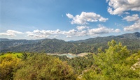
The formation of Cyprus is directly linked to the creation of the Troodos mountain range, as a result of a series of unique and complex geological processes which have made Cyprus a geological model for researchers from around the world, contributing to a better understanding of the development of the oceans and of the planet in general. The peak of Troodos is actually the deepest layer of a section of oceanic crust and the Earth's upper mantle, which was formed 90 million years ago, 8000 metres below sea level.
The Troodos Geopark occupies almost 45% of the total area of the Troodos mountain range and 15% of the total area of Cyprus. Administratively, it belongs to three districts (Nicosia, Paphos and Limassol) and includes 110 villages with a total population of 25 000. The area of the Troodos Geopark is recognised as a geotope with geological, mining, natural and cultural heritage of an outstanding global importance.
Contact information:
Director of Cyprus Geological Survey Departments
Acting Director Mr Christodoulos Hadjigeorgiou
Cyprus Geological Survey Department
Tel.: +357 22409213
Ε-mail: chadjigeorgiou@gsd.moa.gov.cy, etsiolakis@gsd.moa.gov.cy
More information: